James Bay Road website

Chisasibi & LG-1 Road


Chisasibi is a Cree town with a population of over 4000. English, French and Cree are spoken here. Aside from their native tongue of Cree, the Cree of northern Quebec generally speak English rather than French.

West of the gigantic facilities of the La Grande complex, this is the last community accessible by road. Chisasibi is the last community accessible by 
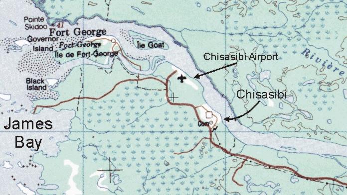
road. Chisasibi, which means "great river" in Cree, was a village originally located on Fort Georges Island, formerly Govenor's Island, which is open to visitors. In 1981, following the signing of the Chisasibi Agreement, the village was relocated to the mainland. Fort Georges was the site of a HBC trading post built in 1837 by Georges Atkinson, a Scottish Metis who gave his name to the island. This strategic location favoured the development of trading links between the different Native communities of the North. As a result, the French and the English fought to monopolize the market. Fort Georges Island is a well-known meeting place and a centre for festivities. Each summer, it hosts a major pow-wow that draws people from everywhere.

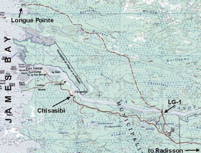
The road to Chisasibi starts at Km 600 of the James Bay Road. This road leads to Hydro Quebec's LG-1 dam and hydro generation station, Chisasibi, Longue Pointe, and to James Bay itself. It is paved all the way to Chisasibi.

Chisasibi is 90km from the James Bay Road, and 110km from Radisson.
James Bay is 108km from the James Bay Road and 128km from Radisson.

Chisasibi Mandow Agency Website: mandow.ca/

More info: (819) 855-2878.

 
From Here to: Km Miles
Amos 872 541
Brisay 728 451
Caniapiscau 812 503
Chibougamau 836 518
Eastmain 442 274
Matagami 690 428
Radisson 110 68
Nemaska 531 329
Waskaganish 555 344
Wemindji 268 166
 
Virtual Tour of the Chisasibi Area - CLICK HERE
 

What to do in Chisasibi

  • Drive to the very end of the Chisasibi Road, which ends at the La Grande River - see the maps and guide below for details. 

  • Drive to James Bay - see the maps and guide below for details. James Bay is a very flat place - all you can see out there are low islands. Most of the islands have no trees, and there are large areas of bare rock. Its beauty is in its remoteness. James Bay is part of the Arctic Ocean. Yet the water is only faintly salty here, because of the number of large rivers that drain into it. There are noticeable tides.

  • Tour the LG-1 power station and dam. Phone (819) 638-8486 or 1-800-291-8486. You must reserve ahead of time. English-speaking tours may be available (?). For more info, see the Hydro-Quebec Project page.

  • Drive to James Bay via LG-1, taking the road to Longue Pointe (unpaved) - see the maps and guide below for details.


Chisasibi


Guide to the Chisasibi Road and Chisasibi area

The Km distances in this guide are measured from the James Bay Road, and do not refer to the Km posts along the road to Chisasibi.
The Km distances in this guide may not be accurate. I have not measured them with my vehicle's odometer. But at least they'll give you an idea of the distances involved.
This road is paved all the way to Chisasibi.

0 Km Junction with Km 600 of the James Bay Road.

62 Km

In the summer of 2002 there was a checkpoint here operated by the local Crees. Part of its purpose is to ensure that alcohol does not enter the town of Chisasibi.

62 Km

Road to LG-1 power station, about 7 km to the north. Tours are available here.
If you continue along the road and cross the LG-1 dam, the road continues for north and west for 48 km to Longue Pointe on James Bay (unpaved).

90 Km

Access to the Cree town of Chisiasibi (the road bypasses the town). Population of about 3500. There are two access roads to the town. 

approx 92.5 Km

Second access road to Chisasibi town. Just past here the pavement ends.

approx 96 Km

Access road to the actual James Bay (12 km away). To find this road, after you pass the access roads to Chisasibi, pass a fenced area to the left, but do not go as far as the airport. Turn left on a well-used gravel road. After about 2.5 km this road forks (you'll pass an old boat on the left side). The right fork leads down the hill to the Fort George Island ferry. The left fork leads to James Bay, about 9.5 km further. This is the Arctic Ocean!
There are picnic tables and shelters there. There are many freighter canoes and snowmobiles lying around. Please respect the property of others.

approx 96.5 Km

Chisasibi Airport

approx 97.5 Km

End of the Chisasibi Road - Km 0 marker. Just ahead of you down the slope is the La Grande River.


MAP of LG-1 and the Chisasibi area


Detail map of the Chisasibi area

 
(photos on this page were not taken by Walter Muma)
Travel Info     Maps    Weather    Roads    Towns    Virtual Tours    Travelogues
Matagami    Waskaganish    Nemaska    Eastmain    Wemindji    Chisasibi    Radisson

The material on this page is copyright © by the original author/artist/photographer. This website is created, maintained & copyright © by Walter Muma
Please respect this copyright and ask permission before using or saving any of the content of this page for any purpose

Thank you for visiting!